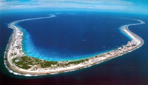
MEGIMI (Mururoa, French Polynesia)
7.2 Power place
Names
– Moruroa (Great Secret)
– Megimi (Sacred Island)
Geomancy
Blue, white and green are the primary colors of the archipelago with its atolls, which seem to float between the sky and the ocean waves. Beneath the ocean surface is found a veritable riot of colors, from lagoons in their various shades of turquoise to shimmering coral reefs in lilac and mauve to yellow, orange, red and pink underwater gardens with fish in all colors of the rainbow. The energys are light and airy, merrily and womanlike as on Hawaii.
Power point
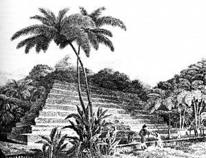
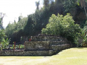
The actual power point in the ley line grid is the island of Megimi in the Moruroa atoll, which is invisible and virtually forgotten today because it lies below sea level. According to legend among the great Marae Polynesians, Megimi was a small volcanic island in the shape of a 7-step pyramid (see page 336 and fig. 7.14).
This was the main energetic power place and a sacred site for the Atlanteans and aboriginal people, a place of experience and a school for the natives of the surrounding islands.
According to Thoth, it was their “holy island”, center and a feminine pole in the Pacific, but it too disappeared in the Great Flood.
– Root corresponds to: chakra, body
– Colors: red, ruby red
– Dominant elements: water and air
– Corresponding place: Taklamakan, China
Note:
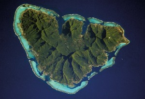
Drunvalo and other sources believe the power point lies near the island Moorea (Mo-orea, which also bears older names including Aimeho and Eimeo), which is situated off the west coast of Tahiti and which belongs to the Society Islands. However, in my opinion, Moorea, with Moruroa, is the closest of the 144 connected power places, and because I am unable to travel in this closed off military zone, I also conducted my energetic and ceremonial processes on Moorea.
Local legends say that the Moorea Atoll is the fin of a giant ancient fish because it is shaped like a symmetrical pyramid. A V-shaped mountain range divides the island, with the 1,200 meters tall Mount Tohiea (Tohvea) in the middle.
7.3 Structures
Main structures
Any structures that may have once existed on the Moruroa atolls now lie below sea level.
Subterranean structures
According to legends, there were also underground caves and complexes, such as Marae Mahaiatea on Tahiti (see page 336).
Other structures in the region
Morongo Uta – Oparo/Rapa Iti Islandi
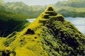
Rapa Iti, which is now often referred to as Rapa, used to bear the old, native name of Oparo. About 900 km from Megimi, the island lies in French Polynesia and is the largest of the Bass Islands (Austral Islands) and the only one that is inhabited. Oparo has a surface area of about 40 km2; its highest mountain is Mont Perau at 650 m above sea level and its main town only boasts 500 inhabitants. What is special about Oparo is the 14 so-called “Pa” or “Pare”, often situated on mountaintops, called “rooms” or “emergency shelters” by the inhabitants, and called strongholds by the later colonialists. They have all been dated to the time between the 11th and 13th century AD, except the “Morongo Uta” with its pyramid-shaped top, which is said to have been built in the first century. There is no evidence or stories that might indicate who built them and for what purpose. The complexes are still largely unexplored, which is why there is so much speculation about them, primarily about whether there are chambers in the pyramid.
Temple structures
Marae (or malae, mala’e, ma’ae)
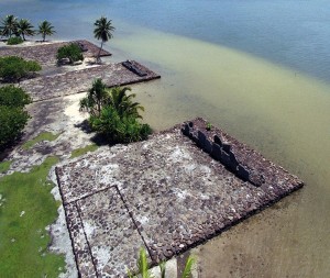
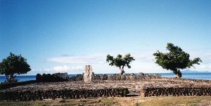
The few remaining structures from early times besides those already mentioned are the marae (which today means “free of trees, bushes and plants”). These are temple complexes and ceremonial worship buildings that, according to academics, were built between 1,000 BC and 1,000 AD
Such marae are found throughout the Polynesian Triangle, from Hawaii in the north to the Austral Islands in the south, from New Zealand in the west to Easter Island in the east. The independent development of the Polynesian archipelagos over thousands of years led to a range of variants and forms of expression, although basic structures remained almost the same. Over time, additional levels were added, with an outer wall made of peg-shaped cut stones joined without mortar.
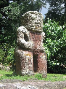
Marae are always rectangular and often pyramid-shaped platforms made of rocks that have a stone platform at their ends on which a statue of the god Tiki sometimes stands (see Figure 7.19). This was the ahu, the holy of holies in the marae, which the rank and file were not allowed to enter. Only the Tahua (priests) were allowed to communicate with supernatural forces and creatures from other worlds there (mostly their deceased leaders or gods).
In ancient times, the marae were considered to be the home of the gods, blessed with mana (spiritual power) and tapu (inviolability) and used exclusively for religious ceremonies. The recitations, songs and dances which have been handed down are also said to have originated at that time.
Later, people used the marae for various social activities. In addition to religious ceremonies, coronations of kings and chiefs as well as trials were held, laws for the people proclaimed, wars declared and victories celebrated there.
The chief‘s seat was placed in the center in front of the ahu with a large vertical stone tablet as a backrest; it was flanked by lower supports for the rest of the tribal leaders. In the last few centuries, councils have governed from the marae, while diplomatic and village meetings have been held there.
According to historical representations from the 18th and 19th centuries, there were carved and probably colorfully painted unu in front of the ahu instead of vertical stone tablets or stone figures. These plain wooden boards were the backrests for the deities, whose to‘o (portrayals) were displayed on the platform during ceremonies. During this period, sacrifices, sometimes even human sacrifices, were also made (Captain James Cook was witness to such a sacrificial ritual on Tahiti in 1774). The components of all these ceremonies are virtually unknown today or can only be found in songs because they were only handed down orally and have since been forgotten.
Note:
The marae have a fascinating similarity with the ahu platforms on Rapa Nui, Easter Island, almost 7,000 km away, where the world-famous figures are found.
This is just a small excerpt from the book GAIA LEGACY.
7. MEGIMI, Mururoa (French Polynesia)
7.1 Landscape 327
– Geography 327
– Geology 328
– Climate 330
– Vegetation 331
7.2 Power place 332
– Names 332
– Geomancy 332
– Power point 332
7.3 Structures 333
– Main structures 333
– Underground complexes 333
– Other structures in the region 333
– Temple structures 333
7.4 History 338
– Traditional history 338
– Finds 341
– Prehistoric history 342
– Builders and peoples 342
– Original purpose 343
– Legends and myths 344
7.5 Spirit 347
– Religions and deities 347
– Spirituality and transmissions 350

